Monday, April 29, 2013

What's Up?

My last post had us on Linda's last spring break trip down into Utah, now we are biding our time waiting for Linda's big day.  If you were to run into her and ask her how many days she has left, she would not hesitate to tell you.  30 day of teaching left in her career.  It is starting to get real close.

What do we do when we are on the big countdown?  We wait, watch the weather, work on the yard, plan and let the realization that she only has a quick count down left before we are able to do everything we have been planning for.

I have been filling my time by working on the yard and house, and when the weather cooperates I go fishing.  Last week I took my brother fishing.  We have never gone fishing together since we were little kids with Dad.  We went out to Hayden lake and fished for Pike. 

We were dragging lures and cruising the shores.  I caught the first fish within the first half hour and then it slowed down.  We fished for several hours and didn't catch anything.  As we turned the boat for the ramp to pull the boat out, Dale caught his fish.  I was glad he caught one and it was good sized!

Kevin Reed as former student at NIC.  In fact he was a student way back in the days when we were building the new Student Union.  That was about 15 years ago.

We fished Hayden but launched at the Honeysuckle boat ramp. Our goal was to catch some Blueback, but they were evading us so we went into shore and started fishing for Crappie.  I was fishing a small jig but it was very slow.  I tossed into shore and reeled slowly back and boom!  I caught a 21 inch trout!  That was very odd. 

Nothing else happened and we came back to the dock by about noon.  It was good being out on the boat and I really enjoyed Kevin's company.

I plan on putting the boat into Coeur d'Alene Lake this week which will make fishing much easier, this will mean I will probably post more about fish.  We will keep you posted on Linda's retirement and if we have any adventures you will be the first to know.

Friday, April 05, 2013

Antelope Island State Park & Home

On Wednesday we talked and decided to leave the Windwhistle area and drive north heading home.  The drive down was to long days and I felt that if we could break it into a three day trip I would feel better when we arrived back in Post Falls.

We packed that night and left the first thing on Thursday morning.  The drive was windy and uneventful.  When ever we had cell phone coverage Linda did research and found a place to camp at Antelope Island State Park.  This park is an actual island in the Great Salt Lake.  You drove out there on a causeway that crossed a bridge.  This allowed them to call it and actual island.

Our camp spot at Antelope Island State Park.
One thing I can tell you about this place was that there were no trees out there.  The camp areas were flat and devoid of any shade. The wind blew the entire time we were there and at times it shook the camper pretty hard.

Linda and Kobi on the shores of the Great Salt Lake.
When we arrived we walked out over the sand beach to the Great Salt Lake.  It was our first time this close to the lake and we found it to be quite strange.  It smelled like a salt marsh that had very little vegetation around it. We were not really impressed.


Sand and salt, Kobi loved it and rolled in it!
The wind blew all night and we left the area at about 6 am.  We drove to Dillon Montana and found a Good Sam RV campground where we used a free night stay coupon that we had.  The showers were very nice and we got our selves cleaned up and refreshed.

Our final leg took us home via I-90 and we arrived in Post Falls at about 1:30 pm. 
I tasted the Great Salt Lake. Yuck!
This buffalo was grazing near our camper.


We Drove the Colorado River Overlook FWD Trail

Back in the Canyonlands National Park we decided that we wanted to do some 4 x 4-ing and so we took a drive out to the Colorado River Overlook.  Our real hard rock four wheeling experience has been very limited, so we look at our guide book for specific information about trail conditions.
On the drive into Canyonlands National Park.

The guide book said that this Jeep trail was about 14 miles long and was considered very easy for Jeep travel.  It stated that there were two difficult areas along the route that would need attention but that the final 1.5 miles were smooth going on slickrock.

We had gathered water sandwiches and some apples and were on our way.

This was an "easy" trail, yeah right!
The first part of the road was very sandy and wound north to the canyon rim hard rock.  We came to the two hard four wheel areas and with some very slow and steep climbing we mad it over them.  They were about my limits as an amateur 4 x 4-er.  The path took us over some rough slickrock and along the rim until about 12 mile in and then we were stopped.
Colorado River is below.


The road continued, but it was much rougher then anything we had covered to this point.  In fact it was the most technical four wheeling that I had ever attempted. 
I looked it over and weighed our options.  I know we probably could have made it, but being in old Stinky Jeep, with regular road tires and no suspension upgrades we felt that we had better not chance it.  Another factor was that we were alone out there, if something happened, it was a 12 mile hike back.  We parked the Jeep and started hiking along the Jeep trail.  Wow, if this was and easy trail I want to see a hard one!  It was a fun hike and we made it back to our Jeep with no problems.  The drive out was fun and Linda took some pictures of me and the Jeep maneuvering along a couple of the harder spots. 

On the way our we stopped and ate lunch enjoying the ending of a great adventure.

Canyonlands - The Day the Weather Came In

Our first trip into Canyonlands National Park was a little bit reconnaissance mixed with some hiking.  We stopped at the park visitor center and picked up our five day park pass for $10.  While there we asked a few questions and then decided what we would do next.

Newspaper Rock
The paved part of the park leads you to several short hiking trails and it also acts as the jumping off place for a large number of longer canyon hikes. We chose to stay close and drove to a trail called Slickrock.  This 2.6 mile hike led you in a circle following the edge of the canyon rim.  It was a nice hike and we had a great time exploring.
After that we went to an area called The Pot Holes and hike around it.  The draw of the Pot Holes area are the rock divots that collect water.  When they are full a special type of pink shrimp hatches from the dirt in the bottom.  The Ranger at the park headquarters was very excited when she talked to us about these shrimp.  She said she thought that the pot holes still had water, but when we arrived we found that all the water was evaporated leaving the pot holes muddy.  We found no shrimp so we had to change our lunch plans back to sandwiches.

From The Pot Holes we drove to a short hike called the Cowboy Cabin loop.  It lead us past an area that has old items left when cowboys used the area for camping.  There were some pictographs on the rock faces and the trail led us up two wood ladders as we hiked.  It was a nice hike and was located in some real cool rock formations.  As we hiked we looked out to the southwest and noticed that the weather was changing and we could see snow clouds moving quickly into the Canyonlands region.


She has just about got it!
As the weather turned we headed out of the park and drove south to Monticello to fill up the Jeep with gas.  The storm moved in and at one point we were driving in a complete whiteout.

We filled the Jeep and headed back to camp.  On the way back everything was back to normal, the sun was out and the snow was gone.  You gotta love spring weather no matter where you are. 


Along the Pot Holes Trail.

Cowboy Cabin Trail.


Granaries


Around our Camp Site

During the time when we were around our camp, Daren and I set out to explore the area southeast of our camp site.  There was a Jeep trail that led back that direction so we took it!  The trail turned out to end about a mile and a half out at the edge of a slickrock cliff.  We looked around and her are a few of the pictures from that outing.

Jeeping with Darren South of camp.
Marcy and Kobi enjoying drinks with Linda.
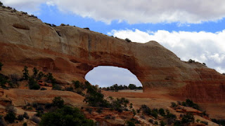
Wilson's Arch
Above is a photo of Wilson's Arch, it can be viewed via highway 191.  We passed it every time we went into Moab or back. I don't know exactlu why the photo got placed here, but this is what happens when you are uploading from your Jeep by the side of the road.

Monday, April 01, 2013

Days 2 & 3 of The Last Spring Break

At 5:30 am the alarm went off and we rolled out of bed.  Linda went directly to the shower and I waited for the camper to warm up before I dragged myself out.  The showers at this KOA were actually very clean and gave you a good covering of hot water.  We took our time in the warmth, who knew when we would get another hot shower, I didn’t.

After the cleanup we packed up the gear, walked Kobi and hit the road.  I filled the truck up with fuel as Linda walked over to Jack in the Box and got us a couple breakfast croissants. We were on the road again and I looked at my watch, 7:07 am, strange very strange.  We probably won’t do that again, two days in a row, on the road at the exact time.
Our site @ Wind Whistle Campground
Our trip was uneventful until we got close to our exit for Price Utah.  The traffic came to an almost tragic standstill.  I had to hit the brakes so hard and with the camper weight we just got stopped in the nick of time.  I actually heard breaks squeal behind us, but we got her stopped.  As we chugged along we passed three separate rear end collisions.  The police were there and it looked like everyone was ok.  The backup of traffic had caused a stop wave and that is where we almost bit it.
Once the traffic cleared out we started driving again but we noticed that the truck was acting funny.  I stepped on the throttle and the diesel would lug way down with no power.  If just stepped on the gas pedal and gave normal throttle then the truck would go through its gears like normal. As we hit the next long hill leading up the pass to Price the engine ran but had no acceleration.  We turned on our safety flashers and chugged on over the top.  Once we were on the downhill everything was fine as long as I didn’t step on the gas pedal.
View South from camp.
Linda got on the phone and called the Dodge dealership in Price and they said to come on in.  We were about 20 miles out and moving just fine.  We arrived and pulled the truck into their work area.  Things were slow for them and that was good for us.  The mechanic ran the diagnostic on the diesel and everything checked out ok.  He scratched his head and then reached over to the air filter and lifted the lid.  The air filter was gone!  Well it was not where it was meant to be, it was sucked up into the top of the filter housing.  That was the problem.  It turned out that the last time I had Dave Smith change the filter; they put in the wrong aftermarket filter.  When we stepped on the throttle it sucked the filter up and clogged the air intake and shut down the turbo.  Wow, I would have never guessed that.
View North from camp.

With the problem solved I had him put a new air filter in and while he was at it I had him change the fuel filter.  I figured why not get that done and keep the truck happy.  In all the project took about an hour and we were back on the road excited that when we wanted power, we got it.
We blasted through Moab; the town was packed from the remaining participants of the national Jeep Rally.  We were glad that we were not staying there, but it made us nervous about finding a spot at the Wind Whistle Campground. It was quite a drive back there from Moab and there was no guarantee we would get a spot. 

We arrived at the campground with our fingers crossed.  To our amazement there were only four sights taken and the best one (in our opinion) was open so we grabbed it.  We set up camp and took a short dog walk before dinner and then we hit the sack, excited to get going exploring this area.  Tomorrow we will decide where we are going hike, but to tell you the truth, I could spend the entire week right here.
Day 3
Linda was up and running early and I made the coffee and tea.  Kobi and I went for a walk and we met Linda as she returned.   We walked back to camp planning the day.
Linda and Kobi @ Needles Overlook.
After breakfast we loaded up the Jeep with Kobi and water and then headed out the road to the Needles Overlook.  What a view! We could see the Colorado River and the White Rim Trail above it.  About fifteen years ago we rode our mountain bikes along the White Rim.  It was an epic trip for us. Jason Luker was the Outdoor Program Coordinator at that time and he said “it will be easy-peasey!”  Needless to say that it was quite a journey for us.  The downhill runs were wild and exhilarating and it took everything I had to do some of the ridge crossings.
Looking over the area brought back great memories and I took as many pictures as I could.  Photos just don’t do justice to the vastness of this area; you really have to see it in person.
After walking the entire area we got back in the Jeep and headed back to camp.  As we drove we passed the road to the Hatch BLM Campground and I said to Linda that we should go at it, so we did.  I turned around and headed out the nine miles to the camp.  It was a dirt road and we were slowed to about 40 mph.  Linda didn’t like the speed, but we did just fine.
Hatch Campground is not a great destination place.  It overlooks the valley and has about eight sites.  Two of them have great views, but we both agreed that if give any choice we would not travel out this far for those spots.
Once we inspected the camp, we headed back.  At the T where you got off the main road to drive to the campground was a sign pointing on down the road to the Anticline Overlook.  I had read a little about this spot and I said “since we’re here, and we may never pass this way again.” We turned right and drove the nine miles out to the Anticline Overlook. 

This spot has more great vistas that include the Colorado River and some of the Pot Ash area. Pot Ash is just down river from Moab and as it indicates there is a big Pot Ash production plant next to the river. I once again took a batch of photos and once finished we loaded up and drove back to our camp at Wind Whistle.
We rested up by taking naps in the sun and then we went for a hike to explore around our camp area.  We walked over to the far cliff faces and then followed the stream bed back to our camp site. 

At about 4:30 pm we received a txt message that Darren and Marcy were on their way and would be to Wind Whistle if a couple of hours. That was a big surprise and we made sure the site next to us was reserved for them.

Darren and Marcy arrived and set up their trailer next to us.  We played a game of Qwirkel and talked.  We went to bed early so we could get an early start the next morning. Our plan was to drive back into Moab and look around.  The weather looked like it was not going to be the best and so it would be a good day to get some things at the store. 


View from the Anticline Overlook.
Our drive in was uneventful, we looked around a bit and decided that there was a bigger crowd then we wanted to deal with so we went to the store for our provisions.  As Linda shopped I uploaded the blog and photos to the web.  Once that was done and Linda was back we were out of that place.  Nice place to visit but…
We drove home and made plans for the next day. Once home we went on a walk behind our camp site.  The area is much bigger than we expected and once we got into the wash we wound around the entire basin.  It was just enough to get us hungry and tired.