In the last post, there were really nice pictures of the dunes with the sun out, blue skies, etc. Shortly after that the wind came up. It blew and blew. We stayed inside most of the day and when we went out we had to put rocks in our pockets to keep from blowing away.
On Tuesday morning, we got up and packed. We then drove on through Boise, planning to camp for a couple days on the Salmon River.
It was a beautiful drive and after we left the Boise valley, the wind went away. We stopped at Ridley's Grocery Store in McCall and bought some road food. Apple Fritters are one of the foods we measure a bakery by. We bought two huge apple fritters and found them to be the best we have ever eaten. They were wonderful! Each one weighed in at almost a ton and the cake was mixed with cinnamon and apples so that each bite was marvelous. We drove on and they were gone in two minutes.
The road took us through New Meadows and up over the pass, finally winding down on to the Salmon River. We enjoyed the change of scenery and found a nice camp spot at Slate Creek and got all set up.
When I tried to start the refrigerator it wouldn't fire. We tried everything to get it to work. We changed the propane tanks and used different hoses and connectors. I tried it all. We were a bit put out, but we decided that it would be best, this close to home, to just move on and get home a couple days early.
We arrived home at about 6:20 PM and Kobi settled right in. We were happy to be in our house and are starting to plan our next outing; once we fix the refrigerator, that is.
Tuesday, April 26, 2016
Monday, April 25, 2016
Dunes
 |
| Sunset over Bruneau Dunes |
 |
| Our rig rests! |
 |
| A water spout in the middle of nowhere. |
 By 6:00 AM the wind had died down and we were able to get on the road. The sun pocked out for about an hour and then everything changed. Once again the wind came up, but this time it was blowing directly at us as we ran north through Salt Lake City. Just past Provo the rain started and several times we were driving in fog and rain so thick we had to slow down.
We entered Idaho and the rain stopped but the wind was relentless. We were driving head on into the wind and our fuel consumption showed it. We made the turn to go to Bruneau Dunes State Park and noticed that we had very little diesel left and so we drove into the town of Bruneau and got $50 worth. From there we drove the six miles to the park and settled in. Everyone is hunkered down and the wind is a roaring.


 Morning came and the wind had died, Linda went out for her run and I walked Kobi. The dunes are not far from the campground and you can see people plodding up to the top of each sand pile. There are two small lakes at the bottom of the two bigger dunes. Kobi and I walked out on the dock on one of the waterways. Beyond the dunes and the couple of lakes, there isn’t much here to see.
Linda and I took the Jeep and drove to a sportsman access road that led us down near the Snake River. We were looking for a waterfall called Crane Falls, but drove around and never did find the falls. We figured it was possibly a dry falls. So that’s our story and we’re sticking to it.
 After that adventure, we drove out along the Bruneau River to an overlook called the Bruneau Canyon Scenic Viewpoint. This overlook is about 800 feet above the river and is a spectacular place to look around.
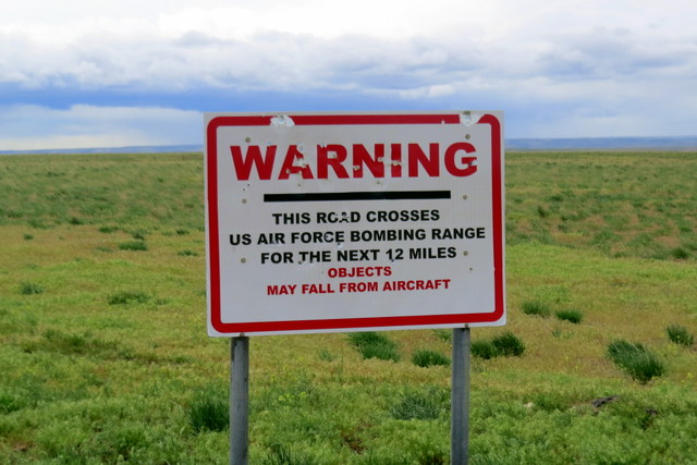
We got to the ridge top and entered the Saylor Creek Air Force Bombing Range. Yup, we ignored the warning signs. I figured we could avoid anything they dropped down on us. Anyway, why would they want to bomb a lapis blue Jeep?
 The viewpoint was about four miles into the range. Below was an amazing view of the river as the water cuts through huge cliffs of lava rock. This is a whitewater river run and as we watched we saw three kayaks disappearing out of site down river. The sign said that the stretch below us was called Five Mile Rapids and it was rated class 5.
  We looked up river and noticed a blue cataraft working hard in the rapids. Looking closer we found that there was a guy standing on a rock on river right and then we noticed three people gathering on river left. A flipped boat came into view below us and the cataraft was trying to catch it. Upriver a kayaker was spotted checking on the four people that were on river right and left. Then he joined the catarafter on river left. The flipped boat went through the rapids and I watched it float out of sight. We knew that we had three people on river left and they were working their way downstream to get together with the others in their group. The guy on river right was OK, but needed to get across to the rest of the group. We didn’t know how many were in the party (we thought we counted 7), but the ones we saw were all OK from our standpoint. All we could do was get in the Jeep and drive.

Working our way back down from the overlook we noticed a small road on our map that said there was a private takeout for river use. We followed some folks into the spot by the river and when they got out of their truck we asked if they were picking up some boaters. Turns out that they were there to meet the group that we watched lose the raft downriver. We asked how many were in the group and they confirmed that the party numbered seven. We were happy to report that everyone was gathering together upstream, but that they had lost the paddle raft downriver. All were concerned, but they said that the group was very experienced and that they were confident they would make their way downriver. We found out that there was about nine miles of slower water after the rapids, so hopefully they could get everyone together and make their way downriver on the cat and catch the flipped boat.
 Linda and I waited around for a while and talked with the folks, but we decided that it was time to get back to camp for lunch and we left. We sure hope everything came out OK for the boaters involved. Like Linda said, it will probably be one of those stories told tonight at a bar that starts “No shit and there I was…”
Lunch was consumed and we rested for a while. Looking west you could see dark clouds building so I suggested that we take a hike over to the dunes and climb to the top of one. Linda was all for that so we hooked Kobi to his long line and we hiked over to the sand piles.
 |
| Breneau Dunes. |
 I had read that the tallest one was over 480 feet tall and Linda said that these were the tallest natural sand dunes in North America. We climbed from one end to the other. A sign in the parking lot said that there was an area where the two sand dunes met that created a vortex crater. No sand is deposited in the vortex area. I stood looking at the vortex in hopes that a pyramid door would beckon, but nothing happened. I guess we have a different sort of vortex here in Idaho than in Sedona.
The weather to the west was looking blacker and more rain-like, so we retired to the camper. Dinner had been in the crock pot all day and we could smell the sesame chicken feast. The dunes provided today, with a little help from Stinky Jeep.
 |
| At the top of the dune. |

 |
| Walking the ridge. |
 |
| WATER! |


Friday, April 22, 2016
The Road North
 |
| Our camp at Jonson Canyon, pre toy haulers. |
Driving days mean that we get up early and then spend at least four hours on the road heading to a new spot. Linda lays out her maps and memorizes all the highway numbers for the upcoming day. She approximates driving times and finds us a place to stop for each night. The distance we drive usually depends upon where we have reservations for camping.
Our next reservations are at a campground up in Idaho. That gives us two nights to make our way up to that campground. To do this Linda talked to Daren and Marcy and found that they camped in a BLM area up Johnson Canyon just outside Kanab. It is boondocking at its best with nothing but a dirt parking lot as you site.
 We drove through some really spectacular country today. Crossing over Glen Canyon Dam, past Page, Arizona, into Utah, entering the Escalante Grand Staircase National Monument; we were never without an interesting view or beautiful panorama.
In comparison, our parking lot camp was very stark, but who can complain at no cost to stay. I hiked up a 4X4 road after we were set up and it gave me the urge to get the Jeep unhooked and take a drive. Wouldn’t you know it, the battery was dead again! Yes, we used our Break Buddy or F#&/%n Buddy as we now call it. So Linda and I started to push the Jeep up to the front of the truck so that we could jump start it.

As we worked to push the rig, a real nice lady came by and offered us a jump start and we happily accepted the offer. Stinky Jeep started right up and we thanked our friend and she drove off. With the Jeep running, I checked the cables and found that the positive side was loose so I spent some time cussing at my tools and finally got it tightened up.
I took a drive up the main Johnson Canyon road to charge the battery and once I figured it was good, I returned to the lot. Since I was right near a 4X4 road I decided to take a drive up over the near hill to see what was out there.
 |
| A group of 20 trail cars being remodeled into a B&B. |
 |
| Cool idea for road side rentals. |
Back at camp, Linda got me a cool drink and we planned our next day’s drive. I fixed dinner and then with the cool night air floating in we cleaned up and went to bed.


Day Two –
Last night at 2:20 AM, three huge toy haulers from Montana, pulled into the BLM lot. Our camper was positioned just past the BLM signage tucked away from the two other camping rigs. There was a huge parking lot empty for all who wanted to camp. The three toy haulers pulled in and made a semi-circle around our camper and then proceeded to unload six ATVs and place then directly in our path. The noise and lights were annoying enough, but imagine our surprise to find that we were blocked and had to back up our truck and Jeep to get out a 6:00 AM this morning. I was a bit pissed and have to admit that I slammed my door whenever possible as I idled our diesel the entire time we loaded and left.
All Linda could say is that those type of inconsiderate actions give ATV operators bad karma. All they needed to do was pull in and go to bed, then set up their personal little ATV village after they woke up at 9:00 AM in the morning. We would have quietly been long gone and the world would be a happier place.
 |
| The view from Utah Lake State Park. |
After we calmed down, we drove into Kanab and stopped at a grocery store where we continued our quest to find the world’s best grocery store breakfast burrito. The fellow behind the counter handed Linda the two burritos and she asked, “What’s in them?” To which he replied, “Everything you see in the display case, except the biscuits and we put gravy in them.” Sold! How can you pass up a burrito with an entire display case of breakfast foods in it!
We drove on down the highway eating our breakfast and comparing those burritos to the others we have eaten as we traveled. Yes, they might be the best we have had so far!
Our drive took us on highway 89 up to the Provo area where we got a camp site at Utah Lake State Park. The weather has been very good all day but by evening, it clouded up and looked a bit like rain. Tomorrow we will drive up into Idaho, our potato state!
Wednesday, April 20, 2016
Vortex Area
 |
| Grasshopper Point |
Stinky Jeep carried us into Sedona. I think he was feeling his oats because finally there were Jeeps around that were painted a color less macho then his lapis blue. Pink Jeeps were everywhere! Our plan was to glide on through the town on highway 89A and do a little sightseeing up the Oak Creek Canyon. I didn’t get to look around yesterday during the drive in and the Jeep provided a great way to see the red rock country.
 |
| Bell Rock (left) and Courthouse Butte (right). |
The highway snakes up the canyon and provides some great views of the many rock formations. One that everyone stops and photographs is called Grasshopper Point. We stopped at the side of the road and captured the red of this area and then moved up the canyon past Slide Rock State Park.
We turned around shortly after this and drove on back into Sedona stopping and taking pics all along the route. When we got into town we came upon the first roundabout and for some reason old Stinky Jeep hugged left and we found ourselves heading out on highway 179.
 |
| Near the VORTEX! No really! |
As we got to Bell Rock, Stinky pulled left again and we found ourselves in one of the vistas facing Bell Rock and Courthouse Butte. Things got a bit strange then. A pyramid shaped doorway stood before us. We exited the Jeep and walked toward the door. As we did, it moved away! Linda said that it was a vortex because she saw it listed on the map we got from the Sedona Chamber of Commerce Visitors Center. A VORTEX! At Bell Rock! Being drawn in its direction we moved closer, but it kept moving just out of our grasp. Linda looked at me and said, “It isn’t our time, I guess!” We jumped back into Stinky and drove back toward downtown. It was all so strange; I can’t be sure what was imagined and what was reality.
 We took a left on Morgan Road and drove out and watched the Pink Jeeps drive up the Broken Arrow Road. There we got some pics of Snoopy Rock. We made our way back down and followed Schnebly Hill Road out and looked at some viewpoints there. It was a very rough road; we had been told that a rancher used the road to drive his cattle herd into Sedona a long time ago. There has been no improvements since. It also was used as the old highway into the town, but now it is just a rough Jeep road. When we both got our fill of being jerked about we turned around and headed back to downtown and found a place for lunch.


 |
| The map from the Visitors Center. |
 |
| Note the Vortex Area near Bell Rock. |
 |
| Map legend. See! |
Tuesday, April 19, 2016
Next Stop...
Today was the day of great changes. We got up early and packed everything for the days trip. I drove the truck to the dump station and Linda brought the Jeep. As I dumped our waists, in the most discussing dump site ever, we hooked the Jeep up and got it ready to tow. Once everything was checked and rechecked, we headed out.
Our destination was a state park outside of Cottonwood, AZ called Dead Horse Ranch State Park. To get there we took state highway 89A down through Oak Creek Canyon, past Sedona and on to the smaller town of Cottonwood.
During this drive, we lost 4000 feet of elevation and gained about 50 degrees of temperature. Our camp spot is in very dry foot hills, just outside the city proper.
Our first mission after set up was to drive back into town and get grocery necessities. Once that was complete we could settle down and enjoy the heat.
Down and Back
 At 6:20 AM this morning I heard my lovely wife squirm out of bed and the next thing I heard was her voice saying, “Get up, we need to get going!” Our plan was to get ready and be on the South Kaibab trail by 8:30 AM. If all worked ou,t we would hike down three miles to Skeleton Point and then back up to the trailhead.
This would be a real test for the new knees and I was a bit concerned. The hardest test climbing had been the three pools climb in Zion and they were a bit tired when we finished that one.
Our timing was perfect and we headed down the trail right on time. There were quite a few hikers, but nothing like on the trail in Zion. At times, we were actually hiking alone basically, though that didn’t last very long before we either caught up with someone or visa versa.
 Once again the canyon provided! The hike was one vista after another on a trail that dropped 1400 feet straight down. We marveled at the hikers coming up from Bright Angle Campground, 7 miles below. As we walked we took in the sights and talked about whether we would want to backpack this trail. Both of us agreed that we probably didn’t want to give up our comfortable bed in the camper.
Hiking down turned out to be quite easy and my knees felt great as we went. We passed our first hiking goal, Ooh Aah Point and descended on. At Cedar Ridge, we stopped and had a snack and used the bathroom provided there.

At 2.09 miles I started to get concerned. What if I turned around at Skeleton Point and found that my knees wouldn’t be strong enough to get me back up the three miles? I got a bit nervous and finally made the decision to turn around and start the climb out.
Linda was great about my decision and she turned around with me. Hiking out was hard, but it turned out to be something that my knees allowed me to do. It was like being on a stair stepper for an hour and a half. I move slowly and steadily trying to make sure each leg was used about the same. We hit the trailhead at about 11:20 AM and celebrated by having lunch overlooking the canyon.


Subscribe to:
Posts (Atom)